What lies under most of Uganda
Away from the sedimentary basins of the Albertine Rift, most of Uganda is underlain by Precambrian crystalline basement: granites, gneisses and schists. Fresh basement rock holds almost no water. What water there is sits in two places: the weathered mantle of decomposed rock, or regolith, that overlies the fresh rock, and the fracture zones that cut through the fresh rock beneath it.
This geology explains why siting matters so much. Two points a few hundred metres apart can have completely different outcomes, because one sits over a deep weathered trough or a fracture and the other sits over shallow fresh rock. Drilling without a survey is not drilling cheaply, it is buying a lottery ticket with a rig attached.
Step one: the desk study
Before anyone walks onto the site, our geologists review what is already known: geological and hydrogeological maps, satellite imagery for lineaments that may indicate fracture zones, drainage patterns, and above all the completion records of existing boreholes nearby. A neighbouring well that struck water at 55 metres is worth more than any theory.
Step two: profiling across the site
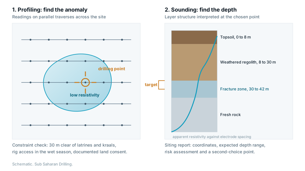
On site, the team runs traverses across the area with electromagnetic or resistivity equipment, taking readings at fixed intervals along each line. What emerges is a profile of apparent conductivity across the landscape. Low resistivity, meaning high conductivity, often indicates thicker weathering or a water-bearing fracture, because water and clay conduct while fresh rock does not.
The result is a shortlist of anomalies: places where the subsurface differs from its surroundings in a way consistent with stored water.
Step three: sounding at the chosen anomaly
Profiling tells you where; sounding tells you how deep. At the strongest anomalies the team runs a vertical electrical sounding, progressively increasing the electrode spacing so that the current samples deeper and deeper. Interpreting the resulting curve gives an estimated layer structure: depth of overburden, depth to fresh rock, and the likely position of any fracture.
That interpretation becomes the expected depth range in the siting report, and it is what the drilling crew works against when deciding whether to continue past the base depth.
Step four: the non-technical constraints
The best geophysical point is worthless if the rig cannot reach it, if it sits 20 metres from a pit latrine, or if the land is disputed. A siting decision therefore also accounts for:
- Distance from latrines, graveyards, cattle kraals and waste pits, to protect the well from contamination.
- Rig access for a heavy vehicle, in the wet season as well as the dry.
- Land ownership and documented community consent.
- Walking distance for the households the water point is meant to serve.
- Drainage, so that the apron and soak pit will actually work.
What a siting report should contain
When Sub Saharan Drilling completes a survey, the client receives a written report with the survey traverses and readings, the interpreted layer structure, GPS coordinates of the recommended drilling point, an expected depth range, an assessment of the risk, and at least one alternative point in case the first proves unproductive. That document is what makes the drilling decision auditable rather than anecdotal.
Questions
Can a survey guarantee that a borehole will produce water?
No. Geophysical surveying substantially raises the probability of a productive well and gives an expected depth, but it maps electrical properties rather than detecting water directly. Any contractor guaranteeing water at a coordinate is overselling.
Can Sub Saharan Drilling drill on a point sited by someone else?
Yes. We are happy to drill against a third-party siting report. We will review it first and tell you plainly if we think the point or the expected depth is wrong, before the rig mobilises.
Talk it through with the drilling team
Estimates are free and carry no obligation. Call +256 793 036 679 or send the details of your site.